

Aviation RF Link

Description de Aviation RF Link
General
________________________________
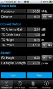
The program Aviation RF Link allows quick calculation of the forward link from a ground station to an aircraft. Based on the RF power of the ground station, the tool calculates the distance with a given field strength to be achieved at the aircraft antenna or calculates the field strength at a given power and distance to the aircraft.
The tool calculates the path loss based on line-of-sight (LOS) conditions and does not take into account multipath propagation on the ground.
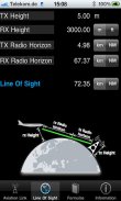
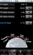
In addition to the RF path, the tool calculates the radio horizon based on the given height of the aircraft and the ground station. If the calculated LOS is lower than the distance that can be achieved with the given radio conditions, this is indicated by a red dot on the LOS tab. In this case, the radio horizon is the limiting factor and not the RF link budget.
The line of sight is calculated in accordance with ICAO Annex 10 Vol. V.
The default for the antenna gain of 2.14 dBi corresponds to an omni directional antenna.
The default for the field strength of 75 uV/m corresponds to the ICAO recommendation for minimum reception at the aircraft antenna.
Quick start
________________________________
To start calculation, just select a row by touching it and change a specific value.
After touching the "Return" button, the dependent values are calculated automatically.
If any value other than distance is changed, the distance is recalculated. If distance is changed, the field strength is recalculated.
If you change a unit, the corresponding numerical values are converted. For example: 1 mW yields 0 dBm if the unit is changed from mW to dBm. Also conversion between feet and meters, and between nautical miles and kilometers is performed.
</div> <div jsname="WJz9Hc" style="display:none">Général
________________________________
Le programme de l'Aviation RF Link permet un calcul rapide de la liaison directe à partir d'une station au sol d'un aéronef. Sur la base de la puissance RF de la station au sol, l'outil calcule la distance avec une intensité de champ donnée à atteindre à l'antenne d'avion ou calcule l'intensité de champ à une puissance donnée et à distance de l'aéronef.
L'outil calcule la perte de trajet sur la base de la ligne de visée (LOS) et les conditions ne prend pas en compte la propagation par trajets multiples sur le sol.
En plus de la voie RF, l'outil calcule l'horizon radio sur la base de la hauteur donnée de l'aéronef et la station au sol. Si la valeur calculée LOS est inférieure à la distance qui peut être atteint avec les conditions radio donnée, cela est indiqué par un point rouge sur l'onglet LOS. Dans ce cas, l'horizon radio est le facteur limitant et non le bilan de liaison RF.
La ligne de visée est calculé conformément à l'Annexe vol 10. V.
La valeur par défaut pour le gain de l'antenne de 2,14 dBi correspond à une antenne omnidirectionnelle.
La valeur par défaut pour l'intensité de champ de 75 uV / m correspond à la recommandation de l'OACI pour une réception au moins à l'antenne de l'appareil.
Démarrage rapide
________________________________
Pour démarrer le calcul, il suffit de sélectionner une ligne en appuyant dessus et modifier une valeur spécifique.
Après avoir touché le bouton "Retour", les valeurs dépendantes sont calculés automatiquement.
Si une valeur autre que la distance est changée, la distance est recalculée. Si la distance est modifiée, la force du champ est recalculé.
Si vous changez une unité, les valeurs numériques correspondantes sont converties. Par exemple: 1 mW rendements 0 dBm si l'unité est changée de mW dBm. Également la conversion entre les pieds et les mètres, et entre les miles nautiques et des kilomètres est effectuée.</div> <div class="show-more-end">


